Reliability & Risk Management

Operational Challenges of the 21st Century

The cyclical encroachment of vegetation around conductors and other assets creates numerous challenges for electric providers of all sizes and in all geographies. This vegetation needs to be remediated to ensure continuity and quality of service, and in many cases to maintain regulatory compliance and adhere to important safety standards. But across thousands of miles of network, it’s difficult for providers to understand exactly where they have critical encroachments that need to be remediated immediately, and where they have encroachments that need to be managed in a future vegetation management cycle. Traditional methods of identifying and quantifying these encroachments are often manual in nature, prohibitively expensive, and a safety risk for field crews and customers.

A 21st Century Solution

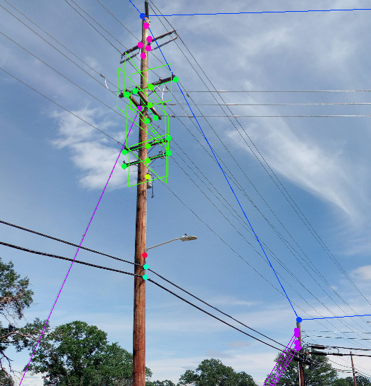
That’s why Cyclomedia has developed an automated, efficient solution that leverages terrestrial data to deliver a complete and precise dataset of all vegetation encroachments across a provider’s network. Starting with our patented vehicle-based data capture, we collect 360°, 100-megapixel panoramic imagery and align it with our high resolution LiDAR point cloud. This creates a true reality capture, upon which we run our suite of machine learning algorithms specifically designed to extract primary and secondary conductors, as well as any additional relevant assets. The algorithms then create radial buffers around these assets, identify vegetation that encroaches within the radials, measure the distance of the encroachment, and create a record to identify its location and severity. The result is a complete dataset that tells the utility precisely where they have critical vegetation encroachments requiring immediate remediation and where they have non-critical encroachments that need to be planned for future vegetation management cycles, delivered in a portable GIS format that easily integrates with existing systems and processes.

Watch Now

Cyclomedia Vegetation Management Solution

img1

Data Capture

See our vehicles, cameras and LiDAR scanners while learning more about our collection process.

Learn more
WE1ITE7N-1

Data Visualization

Bring the field to your desktop with Street Smart, Geocycloramas and LiDAR point clouds.

Learn more
Analytics_2-1

Data Insights

Gain valuable data and insights with our AI-based analytics solutions.

Learn more